2,652  PAGES BROWSED TODAY PAGES TODAY • 0 ANTIQUES UPLOADED TODAYNEW ARRIVALS
GIFTS
LATEST STOCK
Sort Order
Items Per Page
Browse Categories
Sort order
Relevant Links
Items per page
ID #SA612682
FOR SALE
£175
Email Phone Buy
Save
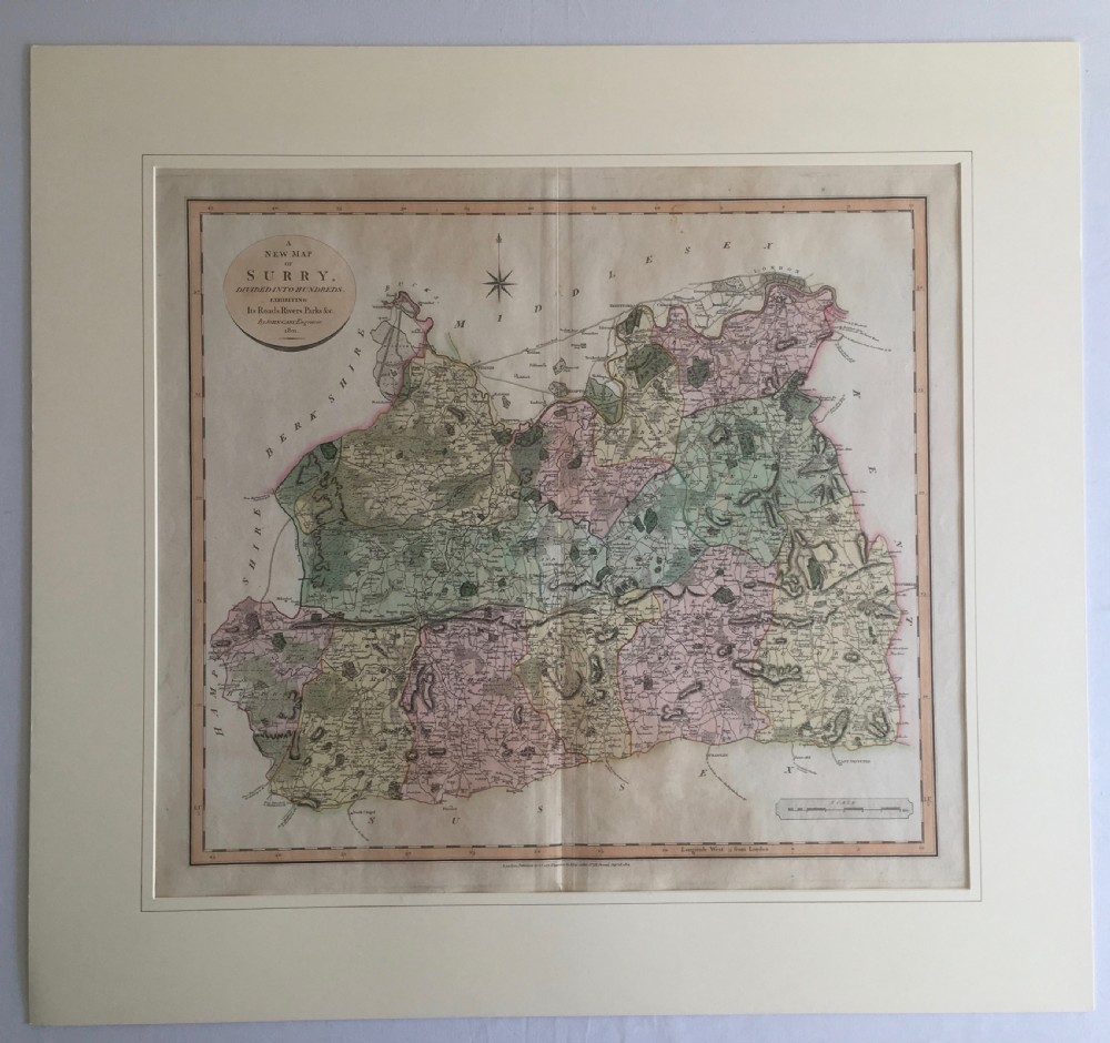
Antique Map of Surry by John Cary 1801
For sale by AJD Antiques
for sale €205     $222
£175
AJD Antiques

AJD Antiques

Sellingantiques Verified Since Feb 2010
Browse dealers 166 items
  • About Us
    Founder of ajd antiques, jonathan dyas has a life-long passion for sourcing and returning to the market an eclectic range of antiques.
Id #SA612682
PDF SHARE
SAVE

Antique Map of Surry by John Cary 1801

19th century
For Sale by AJD Antiques
Description

Hand coloured map by the engraver John Cary of the Strand, London, of Surrey (Surry) divided into hundreds and showing roads, rivers, parks etc in a cream mount. it is in excellent condition.

Size:

Map - 21.25" x 25.25" (54 x 64cm)

Mount - 27.25" x 29.75" (69 x 75.5cm)

Physical Dimensions
Height
69cm (27.17")
Width
76cm (29.92")
Depth
1cm (0.39")
Declaration

AJD Antiques has dated this Antique Surrey County Map to the 1800s.

Reference Numbers
Sellingantiques Reference
SA612682
Dealers Internal Reference
30613B
Description
Hand coloured map by the engraver John Cary of the Strand, London, of Surrey (Surry) divided into hundreds and showing roads, rivers, parks etc in a cream mount. it is in excellent condition.

Size:

Map - 21.25" x 25.25" (54 x 64cm)

Mount - 27.25" x 29.75" (69 x 75.5cm)

Height
69cm (27.17")
Width
76cm (29.92")
Depth
1cm (0.39")
Date of Manufacture

AJD Antiques has dated this Antique Surrey County Map to the 1800s.

Reference Numbers
Sellingantiques Ref
SA612682
Dealers Internal Ref
30613B
AJD Antiques
AJD Antiques
Sellingantiques verified Since Feb 2010

Founder of ajd antiques, jonathan dyas has a life-long passion for sourcing and returning to the market an eclectic range of antiques.

Dealer Profile

You can view the stock and full dealer information on the AJD Antiques Profile Page
PDF SHARE
SAVE
An antique hand-coloured engraved map of Surrey by John Cary, dated 1801, presented on a cream mount with an oval title cartouche.
1 / 5
Archive I An antique hand-coloured engraved map of Surrey by John Cary, dated 1801, presented on a cream mount with an oval title cartouche.

Antique Map of Surry by John Cary 1801

Archive II An antique hand-coloured engraved map of Surrey by John Cary, dated 1801, presented on a cream mount with an oval title cartouche. View II
Archive III An antique hand-coloured engraved map of Surrey by John Cary, dated 1801, presented on a cream mount with an oval title cartouche. View III
Archive IV An antique hand-coloured engraved map of Surrey by John Cary, dated 1801, presented on a cream mount with an oval title cartouche. View IV
Archive V An antique hand-coloured engraved map of Surrey by John Cary, dated 1801, presented on a cream mount with an oval title cartouche. View V
Enlarged Archival View
Location
West London
United Kingdom
Dealer Profile Page sellingantiques.co.uk/ajd
Verified Since Feb 2010
Items For Sale 166
Items Sold 589
AJD Antiques
AJD Antiques
Verified Since Feb 2010
View Dealer Info
Location: West London, United Kingdom
Verified
Feb 2010
For Sale
166
Sold
589
An antique hand-coloured engraved map of Surrey by John Cary, dated 1801, presented on a cream mount with an oval title cartouche.
Antique Map of Surry by John Cary 1801
Ref: SA612682
An antique hand-coloured engraved map of Surrey by John Cary, dated 1801, presented on a cream mount with an oval title cartouche.
Detail View 1
Detail View 2
Detail View 3
Detail View 4
Archival Detail
Every single antique dealer on our platform is individually approved by our internal team. We verify their professional trade history, ethical standards, and photographic quality to ensure a secure, high-standard buying environment. Upon joining, every dealer agrees to a strict 9-point code of conduct. While issues can occasionally arise, our dealers typically resolve them swiftly and directly with the buyer. In fact, since our founding in 2002, Sellingantiques has only had to step in to help resolve an issue on roughly five occasions—a true testament to the quality of our dealers and their dedication to your happiness.
Our dealers are highly experienced in packing and shipping fragile, high-value antiques. Because you are in direct contact with the dealer, you will be able to easily go through all available shipping and insurance options together to ensure your item arrives safely.
Antiques are the ultimate green purchase. By choosing historical pieces over newly manufactured goods, you completely eliminate the carbon footprint of modern mass production while preserving exceptional, timeless craftsmanship.
Written by Sellingantiques from the dealer’s photographs and listing
  • ObjectWall Art
  • Period19th century
  • StyleGeorgian
  • MaterialPaper, Ink, Watercolour
  • ColourCream, Green, Pink
  • MotifsCompass rose, Oval cartouche, Hand-tinted boundaries, Scale bar
  • SizeH 69 cm (27 in) x W 76 cm (30 in) x D 1 cm (0 in)

This Georgian wall art comprises an antique hand-coloured engraved map of Surrey by John Cary, dated 1801, presented inside a cream mount. The paper artwork incorporates delicate green and pink watercolours, defining the hand-tinted boundaries, alongside an oval title cartouche, a compass rose, and a scale bar. Signs of age appear across the toned paper surface, displaying visible creases and minor edge wear. The piece measures 69 cm high, 76 cm wide, and 1 cm deep overall. Suitable for a gentleman's library or study, this framed piece hangs traditionally above a sideboard or console table. The composition introduces historical cartography to domestic interiors, pairing well with traditional wooden furniture and classic wall finishes. The neutral cream mount provides a clean visual boundary that integrates easily with existing period decorative schemes.

John Cary was a prominent English cartographer in the late 18th and early 19th centuries, renowned for his detailed copper-plate engravings and accurate measurements of British roads and counties.

Maps from this era were typically printed via copper-plate engraving onto hand-made rag paper, followed by the application of hand-coloured watercolour washes to delineate regional boundaries.

Authentic Georgian maps feature a distinct plate mark impression around the border, visible paper chain lines or watermarks when held to light, and hand-applied watercolour tinting that varies slightly across copies.

Antique maps can be mounted in contemporary slim moulding or dark wood frames, creating a focal point above a sideboard, inside an office, or as part of a curated gallery wall.

Keep paper maps away from direct sunlight and humid environments, framing them behind UV-protective glass with acid-free mounting materials to prevent yellowing and pigment fading.
items
Add keywords to the filter
Price
£100
£250000
Era
Period
Style
Material
Origin
Stock Location
Recently Added
Online Payments
Categories