25,667  PAGES BROWSED TODAY PAGES TODAY 88 ANTIQUES UPLOADED TODAYNEW ARRIVALS
88 ITEMS ADDED TODAY
Sort Order
Items Per Page
Browse Categories
Sort order
Relevant Links
Items per page
ID #SA1212018
FOR SALE
£600
Email
Save
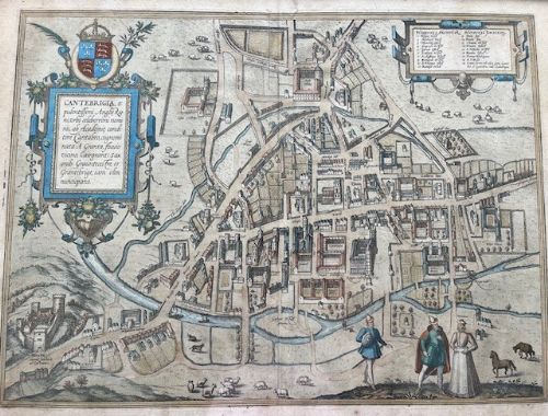
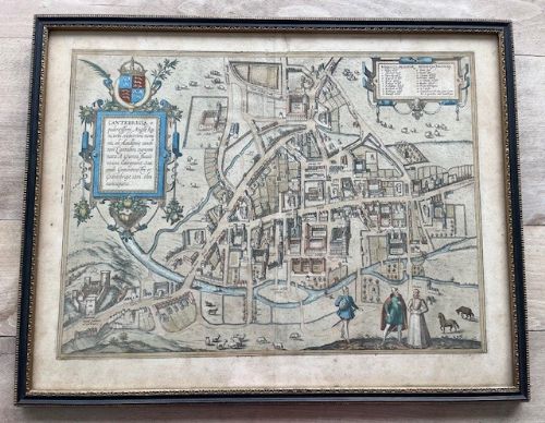
Antique Map of Cambridge (Cantebrigia, Opulentissimi Anglie Regni) by Braun & Hogenberg
Hough & Son
for sale €702     $762
£600

Hough & Son

Sellingantiques Verified Since May 2025
View Dealers Stock Page
  • About Us
    Passionate about unusual antiques, mid-century modern and quirky collectables
Id #SA1212018
PDF SHARE
SAVE

Antique Map of Cambridge (Cantebrigia, Opulentissimi Anglie Regni) by Braun & Hogenberg

Pre 16th century
For Sale by Hough & Son
Description

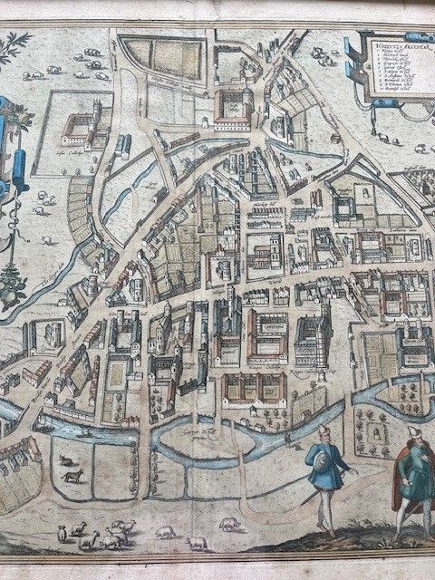
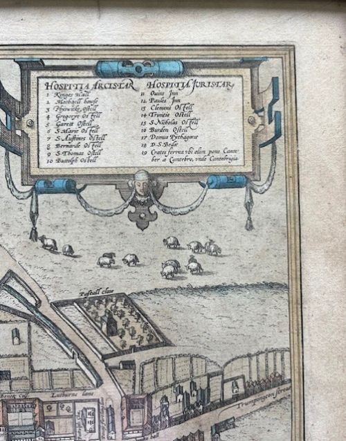
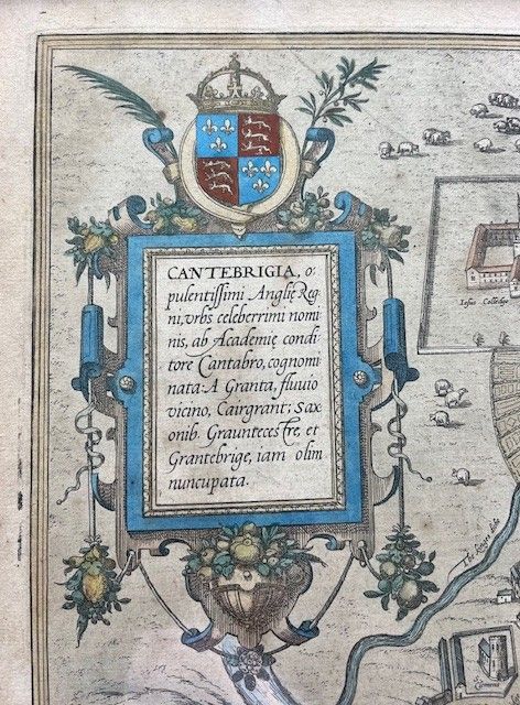
Braun & Hogenberg's engraved double page plan of Cambridge. Includes cartouche, coat of arms and key naming 19 places. It names Trinity College, Kinge's College, Jesus College, Christ's College, Bennett College, Queen's College, St. John's College, Penbroke Hall, Saint Giles, Magealen College, St. Pauls, St. Clemens, St. Johns, Bridge Wardt, Bridge Street, and many other landmarks. Contemporary, hand colouring. Wide margins.
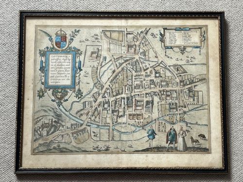
Plate measures approx. 44cms by 33cms. Frame measures approx. 42cms x 53cms.

Central, vertical fold line as one would expect with this particular map.

Good antique condition. Some fading and very slight 'spotting.'

Physical Dimensions
Height
42cm (16.54")
Width
53cm (20.87")
Declaration

Hough & Son has dated this Braun Hogenberg Cambridge Map to a period before the 16th Century.

Reference Numbers
Sellingantiques Reference
SA1212018
Description
Braun & Hogenberg's engraved double page plan of Cambridge. Includes cartouche, coat of arms and key naming 19 places.
It names Trinity College, Kinge's College, Jesus College, Christ's College, Bennett College, Queen's College, St.
Hough & Son

John's College, Penbroke Hall, Saint Giles, Magealen College, St. Pauls, St. Clemens, St. Johns, Bridge Wardt, Bridge Street, and many other landmarks. Contemporary, hand colouring. Wide margins.

fig 1. A framed antique hand-coloured map of Cambridge featuring heraldic crests, a Latin cartouche, and figures in 16th-century dress in the foreground.
fig 1. Antique Map of Cambridge (Cantebrigia, Opulentissimi Anglie Regni) by Braun & Hogenberg

Plate measures approx. 44cms by 33cms. Frame measures approx. 42cms x 53cms.

Central, vertical fold line as one would expect with this particular map.

Good antique condition. Some fading and very slight 'spotting.'

Height
42cm (16.54")
Width
53cm (20.87")
Date of Manufacture

Hough & Son has dated this Braun Hogenberg Cambridge Map to a period before the 16th Century.

Reference Numbers
Sellingantiques Ref
SA1212018
Hough & Son
Sellingantiques verified Since May 2025

Passionate about unusual antiques, mid-century modern and quirky collectables

Dealer Profile

You can view the stock and full dealer information on the Hough & Son Profile Page

PDF SHARE
SAVE
A framed antique hand-coloured map of Cambridge featuring heraldic crests, a Latin cartouche, and figures in 16th-century dress in the foreground.
1 / 7
Archive I A framed antique hand-coloured map of Cambridge featuring heraldic crests, a Latin cartouche, and figures in 16th-century dress in the foreground.

Antique Map of Cambridge (Cantebrigia, Opulentissimi Anglie Regni) by Braun & Hogenberg
Archive II A framed antique hand-coloured map of Cambridge featuring heraldic crests, a Latin cartouche, and figures in 16th-century dress in the foreground. View II
Archive III A framed antique hand-coloured map of Cambridge featuring heraldic crests, a Latin cartouche, and figures in 16th-century dress in the foreground. View III
Archive IV A framed antique hand-coloured map of Cambridge featuring heraldic crests, a Latin cartouche, and figures in 16th-century dress in the foreground. View IV
Archive V A framed antique hand-coloured map of Cambridge featuring heraldic crests, a Latin cartouche, and figures in 16th-century dress in the foreground. View V
Archive VI A framed antique hand-coloured map of Cambridge featuring heraldic crests, a Latin cartouche, and figures in 16th-century dress in the foreground. View VI
Archive VII A framed antique hand-coloured map of Cambridge featuring heraldic crests, a Latin cartouche, and figures in 16th-century dress in the foreground. View VII
Enlarged Archival View
Telephone 07800 952281
Location
Haslemere
Surrey
United Kingdom
Verified Since May 2025
Items For Sale 75
Items Sold 50
Hough & Son
Verified Since May 2025
View Dealer Info
Location: Haslemere, Surrey, United Kingdom
Verified
May 2025
For Sale
75
Sold
50
A framed antique hand-coloured map of Cambridge featuring heraldic crests, a Latin cartouche, and figures in 16th-century dress in the foreground.
Antique Map of Cambridge (Cantebrigia, Opulentissimi Anglie Regni) by Braun & Hogenberg
Ref: SA1212018
A framed antique hand-coloured map of Cambridge featuring heraldic crests, a Latin cartouche, and figures in 16th-century dress in the foreground.
Detail View 1
Detail View 2
Detail View 3
Detail View 4
Detail View 5
Detail View 6
Archival Detail
Every single antique dealer on our platform is individually approved by our internal team. We verify their professional trade history, ethical standards, and photographic quality to ensure a secure, high-standard buying environment. Upon joining, every dealer agrees to a strict 9-point code of conduct. While issues can occasionally arise, our dealers typically resolve them swiftly and directly with the buyer. In fact, since our founding in 2002, Sellingantiques has only had to step in to help resolve an issue on roughly five occasions—a true testament to the quality of our dealers and their dedication to your happiness.
Our dealers are highly experienced in packing and shipping fragile, high-value antiques. Because you are in direct contact with the dealer, you will be able to easily go through all available shipping and insurance options together to ensure your item arrives safely.
Antiques are the ultimate green purchase. By choosing historical pieces over newly manufactured goods, you completely eliminate the carbon footprint of modern mass production while preserving exceptional, timeless craftsmanship.

Georg Braun and Frans Hogenberg published Civitates Orbis Terrarum between 1572 and 1617, creating the first comprehensive atlas of world city views and maps.

Maps from this era were typically etched onto copper plates, printed onto handmade rag paper, and finished with watercolor pigment applied by hand.

Authentic prints feature distinct copperplate indentation marks around the border, visible chain lines in the rag paper, and a central vertical fold where the leaf bound into the atlas.

Framed cartographic prints are often hung in home offices, libraries, or hallway galleries to add narrative interest, dark wood contrast, and historical context.

Keep paper works mounted behind UV-filtering glass with acid-free matting, away from direct sunlight and areas of high humidity to prevent foxing and fading.
items
Add keywords to the filter
Price
£100
£250000
Era
Movements
Material
Origin
Stock Location
Freshness
Online Payments
Categories