28,219  PAGES BROWSED TODAY PAGES TODAY • 101 ANTIQUES UPLOADED TODAYNEW ARRIVALS
GIFTS
101 ITEMS ADDED TODAY
Sort Order
Items Per Page
Browse Categories
Sort order
Relevant Links
Items per page
ID #SA1150716
SOLD
Email Phone
Save
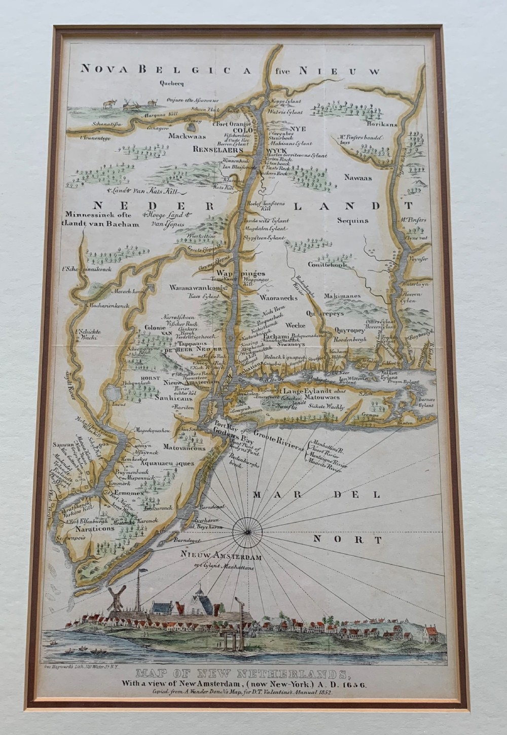
Antique Map of New Netherlands, with a View of New Amsterdam (Now New York) Ad 1656 from D.t. Valentine’s Manual 1852
Sold by Hough & Son
sold SA1150716
Sorry, but this item has been sold.

Hough & Son

Sellingantiques Verified Since May 2025
Browse dealers 71 items
  • About Us
    Passionate about unusual antiques, mid-century modern and quirky collectables
Id #SA1150716
PDF SHARE
SAVE

Antique Map of New Netherlands, with a View of New Amsterdam (Now New York) Ad 1656 from D.t. Valentine’s Manual 1852

19th century
Sold 21 October 2026 · Hough & Son
This “Antique Map of New Netherlands, with a View of New Amsterdam (Now New York) Ad 1656 from D.t. Valentine’s Manual 1852” found a buyer.

It was listed by Hough & Son. Sold pieces stay on Sellingantiques as a record of what has passed through, and the next one is rarely far away.

Description

Antique Map of New Netherlands, with a view of New Amsterdam (now New York) AD 1656 - copied from A. Vanderbilt Donck’s Map, for D.T. Valentine’s Manual 1852

Lithography by Geo. Hayward, 120 Water St., NY.

Frame measures approx. 45.5cms x 31.5cms; visible image measures approx. 32cms x 18.5cms.

In very good, antique condition.

Date of Manufacture

Hough & Son has dated this Antique New Netherlands Map to the 1850s.

Physical Dimensions
Height
45.5cm (17.91")
Width
31.5cm (12.40")
Reference Numbers
Sellingantiques Reference
SA1150716
Description
Antique Map of New Netherlands, with a view of New Amsterdam (now New York) AD 1656 - copied from A. Vanderbilt Donck’s Map, for D.T. Valentine’s Manual 1852

Lithography by Geo. Hayward, 120 Water St., NY.

Frame measures approx. 45.5cms x 31.5cms; visible image measures approx. 32cms x 18.5cms.

In very good, antique condition.

Date of Manufacture

Hough & Son has dated this Antique New Netherlands Map to the 1850s.

Height
45.5cm (17.91")
Width
31.5cm (12.40")
Reference Numbers
Sellingantiques Ref
SA1150716
Hough & Son
Sellingantiques verified Since May 2025

Passionate about unusual antiques, mid-century modern and quirky collectables

Dealer Profile

You can view the stock and full dealer information on the Hough & Son Profile Page
PDF SHARE
SAVE
A framed antique map of New Netherlands featuring a detailed compass rose and an inset panorama illustration of early New Amsterdam along the bottom. SOLD21 OCT 26
1 / 5
Archive I A framed antique map of New Netherlands featuring a detailed compass rose and an inset panorama illustration of early New Amsterdam along the bottom. SOLD21 OCT 26

Antique Map of New Netherlands, with a View of New Amsterdam (Now New York) Ad 1656 from D.t. Valentine’s Manual 1852

Archive II A framed antique map of New Netherlands featuring a detailed compass rose and an inset panorama illustration of early New Amsterdam along the bottom. View II
Archive III A framed antique map of New Netherlands featuring a detailed compass rose and an inset panorama illustration of early New Amsterdam along the bottom. View III
Archive IV A framed antique map of New Netherlands featuring a detailed compass rose and an inset panorama illustration of early New Amsterdam along the bottom. View IV
Archive V A framed antique map of New Netherlands featuring a detailed compass rose and an inset panorama illustration of early New Amsterdam along the bottom. View V
Enlarged Archival View
Telephone 07800 952281
Location
Haslemere
Surrey
United Kingdom
Verified Since May 2025
Items For Sale 71
Items Sold 55
Hough & Son
Verified Since May 2025
View Dealer Info
Location: Haslemere, Surrey, United Kingdom
Verified
May 2025
For Sale
71
Sold
55
A framed antique map of New Netherlands featuring a detailed compass rose and an inset panorama illustration of early New Amsterdam along the bottom.
Antique Map of New Netherlands, with a view of New Amsterdam (now New York) AD 1656 from D.T. Valentine’s Manual 1852
Ref: SA1150716
A framed antique map of New Netherlands featuring a detailed compass rose and an inset panorama illustration of early New Amsterdam along the bottom.
Detail View 1
Detail View 2
Detail View 3
Detail View 4
Archival Detail
Every single antique dealer on our platform is individually approved by our internal team. We verify their professional trade history, ethical standards, and photographic quality to ensure a secure, high-standard buying environment. Upon joining, every dealer agrees to a strict 9-point code of conduct. While issues can occasionally arise, our dealers typically resolve them swiftly and directly with the buyer. In fact, since our founding in 2002, Sellingantiques has only had to step in to help resolve an issue on roughly five occasions—a true testament to the quality of our dealers and their dedication to your happiness.
Our dealers are highly experienced in packing and shipping fragile, high-value antiques. Because you are in direct contact with the dealer, you will be able to easily go through all available shipping and insurance options together to ensure your item arrives safely.
Antiques are the ultimate green purchase. By choosing historical pieces over newly manufactured goods, you completely eliminate the carbon footprint of modern mass production while preserving exceptional, timeless craftsmanship.
Written by Sellingantiques from the dealer’s photographs and listing
  • ObjectWall Art
  • Period19th century
  • Style19th Century Cartography
  • MaterialPaper, Ink, Glass, Wood
  • ColourCream and Beige
  • MotifsCompass rose, inset settlement view, cartographic topography, Latin text
  • SizeH 45.5 cm (18 in) x W 31.5 cm (12 in)

This nineteenth-century wall art piece comprises a paper map with black ink and hand-applied cream and beige tones, protected by glass within a simple wooden frame featuring clean rectangular mitred joints and a warm brown timber finish. The composition displays a detailed historical chart of New Netherlands, Latin inscriptions, a compass rose, and an illustrative panoramic view of early New Amsterdam situated along the lower margin. Visible details include crisp lithographic lines, subtle age toning across the paper surface, and a publisher inscription from Geo. Hayward at the bottom edge. The overall frame measures 45.5 cm high by 31.5 cm wide. This item suits placement above a sideboard in a study or hallway.

Originally created by Adriaen van der Donck in 1656, this cartographic rendering documented the Dutch colony of New Netherland and featured one of the earliest published views of New Amsterdam, which later became New York City.

Mid-19th-century maps, such as those printed for historical manuals, were typically produced using lithography or steel-plate engraving on woven paper, often finished with hand-applied watercolour tinting along borders and coastlines.

Authentic prints from this era feature distinct plate marks or stone lines, age-appropriate paper toning, and subtle variations in hand-tinted watercolours rather than uniform modern dot-matrix printing.

Framed historical maps work exceptionally well as focal points above sideboards, within gallery walls, or paired with dark timber furniture and brass accents in study spaces.

Display paper prints away from direct sunlight using UV-protective glass and acid-free mounting materials to prevent fading, yellowing, and paper brittle degradation.
items
Add keywords to the filter
Price
£100
£250000
Era
Period
Style
Material
Origin
Stock Location
Recently Added
Online Payments
Categories