44,405  PAGES BROWSED TODAY PAGES TODAY • 129 ANTIQUES UPLOADED TODAYNEW ARRIVALS
GIFTS
129 ITEMS ADDED TODAY
Sort Order
Items Per Page
Antiques dealer?
Join as a Seller
Browse Categories
Sort order
Relevant Links
Items per page
for sale
€35     $38
£30
Selling price
This piece comes with
Sellingantiques.co.ukShipping & CheckoutTM
  • Instant purchase
  • Instant shipping quote
  • Fully insured delivery
  • Live tracking
  • 14-day returns
  • Delivered to your door
Get live shipping price
Strickland & Russell

Strickland & Russell

Sellingantiques Verified Since Sep 2018
Browse dealers 285 items
  • About Us
    Yorkshire based art dealers specialising in 19th century & early 20th century oil paintings & watercolours
↓ Relevant Links
Id #SA1237439
PDF SHARE
SAVE

Original Antique C1840 Thomas Moule Warwickshire Map Warwick Castle Kenilworth English Map with Decorative Illustrations

19th century
Description

Type of Artwork: Original 19th Century Antique Engraved Map

Title: Warwickshire

Date of publication: Circa 1840. Exact edition unconfirmed.

Surface: Paper, engraved map.

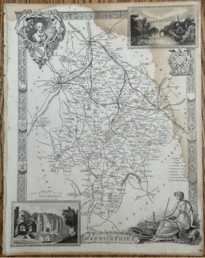
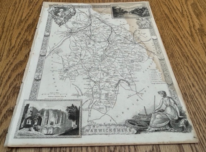
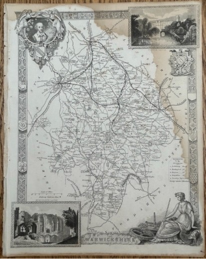
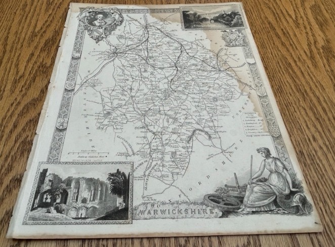
Details: An original decorative county map of Warwickshire by Thomas Moule. Shows Warwick, Coventry, Stratford-upon-Avon, Birmingham, Rugby and surrounding towns and villages, with roads, railways, rivers and county divisions. Decorated with a portrait of Shakespeare, heraldic arms, a view of Warwick Castle, a view of Kenilworth Castle and a classical female figure.

An attractive Victorian map for collectors of Warwickshire, Shakespeare or local history, or for framing.

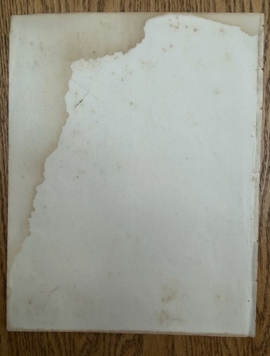
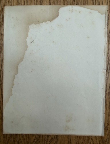
Condition Report: Fair antique condition. General age-related toning, foxing and staining. There is a large area of old water staining across the upper and right side of the sheet, also clearly visible on the reverse. Some edge wear, small tears and minor losses are present. The engraved image remains clear and highly decorative. Supplied unframed. Please inspect photographs for full details.

Size 21 x 28 cm

Date of Manufacture

Strickland & Russell has dated this Thomas Moule Warwickshire Map to the 1850s.

Independent Date Guide ID 09662073
Dealer's Item Date1850s
Sellingantiques Date1850s
Sellingantiques agingItem 165-190 years old
ResultsDates match
Why Sellingantiques dated this piece to THE 1850s:
Steel-engraved lines and vignettes: mid-19th century printing.
Sewing holes along the left margin: taken from a bound atlas.
Paper shows natural toning, foxing and an old tide line from moisture.
Railway network marked: typical of maps revised during the mid-Victorian railway expansion.

This Independent Date Guide is compiled by Sellingantiques using its own proprietary system. It works only from the photographs shown on this page and is never told the date the dealer has declared. It is a guide, not a guarantee of age, and occasional errors can occur.
Physical Dimensions
Height
28cm (11.02")
Width
21cm (8.27")
Depth
0.02cm (0.01")
Reference Numbers
Sellingantiques Reference
SA1237439
Dealers Notes

***************

*Our prices include fully insured UK delivery. We are able to quote for International delivery upon request.

*Your purchased painting will be securely packaged and posted via Insured Royal Mail or Parcelforce delivery within 2 working days of receiving payment.

*We are happy to receive payment via the PayPal platform which accepts most debit and credit cards. Please contact us to enquire about other payment methods.

*If a painting is framed, the frame will be provided free of charge and we cannot offer any warranty for the condition or damage to a frame as a result of delivery. Original frames will have wear in line with age. We consider glass to be part of the frame, and as a restricted item is not warranted . Glass can be removed prior to shipping at the buyers request.

*In the unlikely event that you are not happy with your purchase, for any reason, we will always accept returns and offer a no quibble refund if notified within 14 days of receiving the item and returned to us in the same condition. The buyer is however, liable for the return postal charges.

***************

A monochrome 19th-century steel-engraved map of Warwickshire featuring decorative architectural borders, vignette illustrations of Warwick Castle and Kenilworth Castle, and heraldic crests.Detail view 1Detail view 2
1 / 3
1850s · SA1237439
Original Antique C1840 Thomas Moule Warwickshire Map Warwick Castle Kenilworth English Map with Decorative Illustrations
£30€35    $38
This piece comes with
Sellingantiques.co.ukShipping & CheckoutTM
  • Instant purchase
  • Instant shipping quote
  • Fully insured delivery
  • Live tracking
  • 14-day returns
  • Delivered to your door
Get live shipping price
Description
Type of Artwork: Original 19th Century Antique Engraved Map

Title: Warwickshire

Date of publication: Circa 1840. Exact edition unconfirmed.

Surface: Paper, engraved map.

Details: An original decorative county map of Warwickshire by Thomas Moule. Shows Warwick, Coventry, Stratford-upon-Avon, Birmingham, Rugby and surrounding towns and villages, with roads, railways, rivers and county divisions. Decorated with a portrait of Shakespeare, heraldic arms, a view of Warwick Castle, a view of Kenilworth Castle and a classical female figure.

An attractive Victorian map for collectors of Warwickshire, Shakespeare or local history, or for framing.

Condition Report: Fair antique condition. General age-related toning, foxing and staining. There is a large area of old water staining across the upper and right side of the sheet, also clearly visible on the reverse. Some edge wear, small tears and minor losses are present. The engraved image remains clear and highly decorative. Supplied unframed. Please inspect photographs for full details.

Size 21 x 28 cm
Date1850s
Height28cm (11.02")
Width21cm (8.27")
Depth0.02cm (0.01")
ReferenceSA1237439
Strickland & Russell
Strickland & RussellSellingantiques verified since Sep 2018

Yorkshire based art dealers specialising in 19th century & early 20th century oil paintings & watercolours
PDF SHARE
SAVE
£30plus delivery
Get delivery price
Archive I A monochrome 19th-century steel-engraved map of Warwickshire featuring decorative architectural borders, vignette illustrations of Warwick Castle and Kenilworth Castle, and heraldic crests.

Original Antique C1840 Thomas Moule Warwickshire Map Warwick Castle Kenilworth English Map with Decorative Illustrations
Archive II A monochrome 19th-century steel-engraved map of Warwickshire featuring decorative architectural borders, vignette illustrations of Warwick Castle and Kenilworth Castle, and heraldic crests. View II
Archive III A monochrome 19th-century steel-engraved map of Warwickshire featuring decorative architectural borders, vignette illustrations of Warwick Castle and Kenilworth Castle, and heraldic crests. View III
Enlarged Archival View
Telephone 07504 958608
Location
Wilberfoss
York
East Riding of Yorkshire
United Kingdom
Verified Since Sep 2018
Items For Sale 285
Items Sold 3,304
Strickland & Russell
Verified Since Sep 2018
View Dealer Info
Location: Wilberfoss, York, East Riding of Yorkshire, United Kingdom
Verified
Sep 2018
For Sale
285
Sold
3,304
A monochrome 19th-century steel-engraved map of Warwickshire featuring decorative architectural borders, vignette illustrations of Warwick Castle and Kenilworth Castle, and heraldic crests.
Original Antique c1840 Thomas Moule Warwickshire Map Warwick Castle Kenilworth English Map with Decorative Illustrations
Ref: SA1237439
A monochrome 19th-century steel-engraved map of Warwickshire featuring decorative architectural borders, vignette illustrations of Warwick Castle and Kenilworth Castle, and heraldic crests.
Detail View 1
Detail View 2
Archival Detail
Every single antique dealer on our platform is individually approved by our internal team. We verify their professional trade history, ethical standards, and photographic quality to ensure a secure, high-standard buying environment. Upon joining, every dealer agrees to a strict 9-point code of conduct. While issues can occasionally arise, our dealers typically resolve them swiftly and directly with the buyer. In fact, since our founding in 2002, Sellingantiques has only had to step in to help resolve an issue on roughly five occasions—a true testament to the quality of our dealers and their dedication to your happiness.
Our dealers are highly experienced in packing and shipping fragile, high-value antiques. Because you are in direct contact with the dealer, you will be able to easily go through all available shipping and insurance options together to ensure your item arrives safely.
Antiques are the ultimate green purchase. By choosing historical pieces over newly manufactured goods, you completely eliminate the carbon footprint of modern mass production while preserving exceptional, timeless craftsmanship.
Written by Sellingantiques from the dealer’s photographs and listing
  • ObjectAntique Maps
  • Period19th century
  • StyleVictorian
  • MaterialPaper, Ink
  • ColourMonochrome, Cream, Black
  • MotifsArchitectural vignettes, heraldic crests, ornamental borders, allegorical cartouche
  • SizeH 28 cm (11 in) x W 21 cm (8 in) x D 0.02 cm (0 in)

This original Victorian map of Warwickshire is a paper sheet measuring 28 cm high, 21 cm wide, and 0.02 cm deep. The monochrome steel-engraved artwork uses black ink on a cream background, presenting a detailed cartographic layout decorated with architectural vignettes, heraldic crests, ornamental borders, and an allegorical cartouche. Visible signs of age include general toning, foxing, staining, edge wear, small tears, and minor paper losses, alongside a prominent old water stain affecting the upper and right edges. The engraved image remains clear and highly decorative. Appropriate for a gentleman's library or a narrow wall space, the map works well when framed and hung in a study, hallway, or living room. It provides a classic historic focal point for collectors of local history, Shakespeare memorabilia, or antique cartography, complementing traditional interiors and academic workspaces.

Thomas Moule maps are early 19th-century steel-engraved British county maps famous for their highly ornate, architectural borders, coats of arms, and detailed topographical vignettes.

These prints were produced using fine line steel-plate engraving techniques on woven rag paper, allowing for dense cartographic detail and intricate border illustrations.

Authentic period maps feature distinct plate impression marks around the image border, age-appropriate paper oxidation, and sharp engraving lines characteristic of original steel plates.

Mounting the print in a simple dark wood or gilded frame creates a focal point above a desk, within a hallway gallery wall, or above a sideboard.

Frame paper prints behind UV-filtering glass using acid-free mounting materials, and store or display them away from direct sunlight and damp environments.
items
Add keywords to the filter
Price
£100
£250000
Era
Period
Style
Material
Origin
Stock Location
Recently Added
Online Payments
Categories

Original Antique C1840 Thomas Moule Warwickshire Map Warwick Castle Kenilworth English Map with Decorative Illustrations

£30 · sold by Strickland & Russell
No delivery needed?
I will collect it, or arrange my own shipping£0