3,159  PAGES BROWSED TODAY PAGES TODAY 0 ANTIQUES UPLOADED TODAYNEW ARRIVALS
LATEST STOCK
Sort Order
Items Per Page
Browse Categories
Sort order
Relevant Links
Items per page
ID #SA1158468
SOLD
Email Phone
Save
John Speed Map of Surrey. A Rare 1611 First Edition
Sold by The Ark Stores
sold SA1158468
Sorry, but this item has been sold.

The Ark Stores

Sellingantiques Verified Since Jun 2016
Browse dealers 50 items
Id #SA1158468
PDF SHARE
SAVE

John Speed Map of Surrey. A Rare 1611 First Edition

17th century
Description

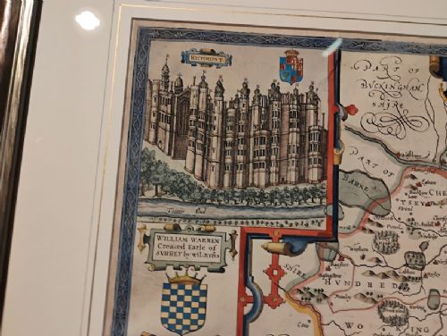
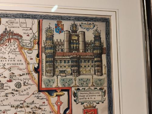
A 1611 first edtion map of Surrey from the 'Theatre of Great Britain' with inset views of the palaces of Richmond and Nonsuch, both royal Tudor residences which were demolished by the end of the seventeenth century. Nonsuch was given by Charles II to Barbara, Countess of Castlemaine, who then tore it apart to pay gambling debts; Richmond was sold by Parliament after the execution of Charles I. In good overall condition with clear, crisp and sharp deliniation. Excellent later hand colouring. The map has been recently professionally framed and glazed to both front and back, the front using anti-reflective glass with 70% UV protection .

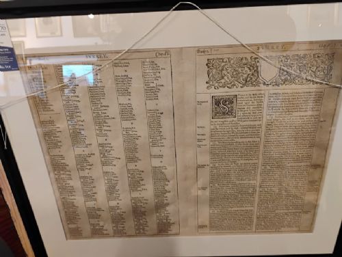
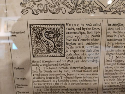
After this first edition of John Speed's map of Surrey was printed, the copper plate was damaged and the top left hand corner in all the subsequent editions are either missing or recreated by hand in watercolour. English text to verso and the style of the capital 'S' in the cartouch confirms that this is the original condition.

Physical Dimensions
Height
59cm (23.23")
Width
72cm (28.35")
Depth
3cm (1.18")
Declaration

The Ark Stores has dated this Framed John Speed Map to the 17th Century.

Reference Numbers
Sellingantiques Reference
SA1158468
Description
A 1611 first edtion map of Surrey from the 'Theatre of Great Britain' with inset views of the palaces of Richmond and Nonsuch, both royal Tudor residences which were demolished by the end of the seventeenth century.
Nonsuch was given by Charles II to Barbara, Countess of Castlemaine, who then tore it apart to pay gambling debts; Richmond was sold by Parliament after the execution of Charles I.
The Ark Stores

In good overall condition with clear, crisp and sharp deliniation. Excellent later hand colouring. The map has been recently professionally framed and glazed to both front and back, the front using anti-reflective glass with 70% UV protection .

fig 1. A framed seventeenth-century map of Surrey by John Speed, complete with heraldic crests and architectural inset illustrations.
fig 1. John Speed Map of Surrey. A Rare 1611 First Edition

After this first edition of John Speed's map of Surrey was printed, the copper plate was damaged and the top left hand corner in all the subsequent editions are either missing or recreated by hand in watercolour. English text to verso and the style of the capital 'S' in the cartouch confirms that this is the original condition.

Height
59cm (23.23")
Width
72cm (28.35")
Depth
3cm (1.18")
Date of Manufacture

The Ark Stores has dated this Framed John Speed Map to the 17th Century.

Reference Numbers
Sellingantiques Ref
SA1158468
The Ark Stores
Sellingantiques verified Since Jun 2016
Dealer Profile

You can view the stock and full dealer information on the The Ark Stores Profile Page

PDF SHARE
SAVE
A framed seventeenth-century map of Surrey by John Speed, complete with heraldic crests and architectural inset illustrations.
1 / 7
Archive I A framed seventeenth-century map of Surrey by John Speed, complete with heraldic crests and architectural inset illustrations.

John Speed Map of Surrey. A Rare 1611 First Edition
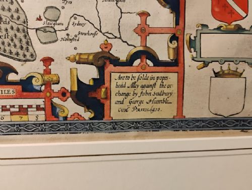
Archive II A framed seventeenth-century map of Surrey by John Speed, complete with heraldic crests and architectural inset illustrations. View II
Archive III A framed seventeenth-century map of Surrey by John Speed, complete with heraldic crests and architectural inset illustrations. View III
Archive IV A framed seventeenth-century map of Surrey by John Speed, complete with heraldic crests and architectural inset illustrations. View IV
Archive V A framed seventeenth-century map of Surrey by John Speed, complete with heraldic crests and architectural inset illustrations. View V
Archive VI A framed seventeenth-century map of Surrey by John Speed, complete with heraldic crests and architectural inset illustrations. View VI
Archive VII A framed seventeenth-century map of Surrey by John Speed, complete with heraldic crests and architectural inset illustrations. View VII
Enlarged Archival View
Telephone 01428 641817
Location
Town Car Park
Haslemere
Surrey
GU27 2HG
United Kingdom
Dealer Profile Page sellingantiques.co.uk/ark
Verified Since Jun 2016
Items For Sale 50
Items Sold 698
The Ark Stores
Verified Since Jun 2016
View Dealer Info
Location: Town Car Park, Haslemere, Surrey, GU27 2HG, United Kingdom
Verified
Jun 2016
For Sale
50
Sold
698
A framed seventeenth-century map of Surrey by John Speed, complete with heraldic crests and architectural inset illustrations.
JOHN SPEED MAP OF SURREY. A rare 1611 first edition
Ref: SA1158468
A framed seventeenth-century map of Surrey by John Speed, complete with heraldic crests and architectural inset illustrations.
Detail View 1
Detail View 2
Detail View 3
Detail View 4
Detail View 5
Detail View 6
Archival Detail
Every single antique dealer on our platform is individually approved by our internal team. We verify their professional trade history, ethical standards, and photographic quality to ensure a secure, high-standard buying environment. Upon joining, every dealer agrees to a strict 9-point code of conduct. While issues can occasionally arise, our dealers typically resolve them swiftly and directly with the buyer. In fact, since our founding in 2002, Sellingantiques has only had to step in to help resolve an issue on roughly five occasions—a true testament to the quality of our dealers and their dedication to your happiness.
Our dealers are highly experienced in packing and shipping fragile, high-value antiques. Because you are in direct contact with the dealer, you will be able to easily go through all available shipping and insurance options together to ensure your item arrives safely.
Antiques are the ultimate green purchase. By choosing historical pieces over newly manufactured goods, you completely eliminate the carbon footprint of modern mass production while preserving exceptional, timeless craftsmanship.

John Speed was a prominent English cartographer who published The Theatre of the Empire of Great Britaine in 1611. His maps were landmark works of cartography, renowned for including detailed inset town plans, royal residences, and county armorial bearings.

Maps from this period were printed using copperplate engraving techniques onto handmade rag paper. Many examples were subsequently hand-coloured using mineral-based pigments and inks.

Authentic first-edition prints typically feature a distinct central fold from the atlas binding, a visible copperplate impression edge, English text printed on the reverse (verso), and characteristic watermarks within the laid paper.

Antique maps function as ideal focal points when framed classically and placed above a sideboard, fireplace mantel, or desk. They complement dark wood furniture, leather accents, and traditional or eclectic gallery walls.

To prevent fading and deterioration, display paper maps away from direct sunlight using UV-protective glass. Mount the paper using acid-free, conservation-grade materials and maintain a stable humidity level.
items
Add keywords to the filter
Price
£100
£250000
Era
Movements
Material
Origin
Stock Location
Freshness
Online Payments
Categories