





Gilt Framed Wall Map
These gilt framed wall map examples bring historic cartography and needlework into rooms, offering a tangible connection to past geography and decorative arts.
Gilt Framed Wall Map
When you search for a gilt framed wall map, you encounter engraved county maps, town plans, and textile samplers originating from seventeenth-century productions up to Victorian and later periods. English and Dutch cartography dominates the selection, featuring works associated with historical mapmakers and atlas publications.
The material forms on this page range from paper atlas engravings and lithography to linen-backed textile art and needlework samplers. These pieces span Dutch Golden Age aesthetics, Georgian refinement, and Victorian framing traditions.
Buyers frequently find seventeenth-century county and world maps alongside eighteenth-century regional surveys and nineteenth-century town plans. Each iteration presents a distinct view of historical topography encased in period surrounds.
Materials and construction
The physical objects combine paper, ink, and linen supports housed within wood frames finished with gold leaf or giltwood. Engraved lines on paper or atlas pages form the basis of the cartographic works, sometimes accompanied by hand-applied colour.
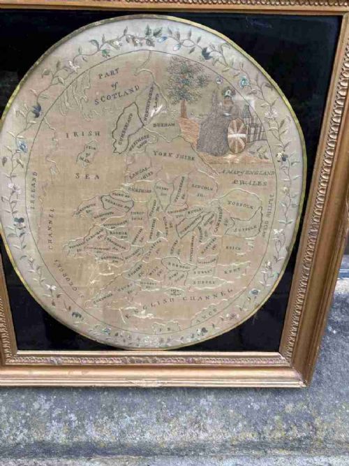
Needlework and embroidery maps utilise textile grounds and thread to stitch geographical layouts rather than using ink on paper. Glazed protective frontages and wooden backing structures secure these delicate maps for wall display.
Mary Pinfold stitched an early Regency embroidery map of England and Wales, proving geography homework once required serious needle skills.
Factors of quality and distinction
Quality rests upon the clarity of the original cartographic engraving, the crispness of the ink impressions, and the preservation of the paper or textile surface. Early impressions taken directly from copper plates display finer line definition than later printings.
The integrity of the giltwood or gold leaf frame contributes significantly to the overall piece, alongside the survival of contemporary colouring and stable backing materials. Samplers and embroidered maps vary according to the complexity of the stitchwork and the preservation of the fabric ground.
John Speed·Joan Blaeu·Johannes Janssonius·Robert Morden·Thomas Kitchin·Eman Bowen
The Gilt Framed Wall Map Glossary
- Cartography
- The science or practice of drawing maps. This encompasses both printed atlas engravings and hand-stitched geographical representations.
- Atlas engraving
- A map printed from an engraved metal plate for inclusion in a bound collection of maps. These form a large proportion of the framed cartography available.
- Needlework sampler
- A piece of textile art created by stitching letters, numbers, or maps onto a fabric ground. Examples include embroidered maps of England and Wales.
- Giltwood
- Wood carved and covered with a thin layer of gold leaf or gilt. This material provides the bright decorative border typical of these wall displays.
- Town plan
- A detailed map depicting the layout of a specific urban area or dockyard. These provide micro-level historical data compared to county or world maps.
Gilt Framed Wall Map: Frequently Asked Questions
What periods do these maps cover?
The selection spans from the seventeenth century through the Georgian and Victorian eras up to the early twentieth century. Cartographic styles shift from early Dutch Golden Age plates to detailed English county surveys.
Specific dates on the maps, such as those from the sixteen-hundreds or seventeen-hundreds, reflect the original publication year of the plate or the execution date of a textile sampler.
How were needlework maps made?
Needlework maps were stitched by hand using thread on a fabric ground, functioning as both educational exercises and decorative wall art. Young makers practised geography and embroidery simultaneously.
These textile pieces are framed behind glass to protect the delicate fabric and threads from environmental damage over the centuries.
Are these original antique maps?
The listings comprise period engravings, atlas plates, and historical textiles produced in the centuries indicated by the titles. Many derive from influential historic atlases and cartographic publications.
Each piece reflects the printing and publishing standards of its specific era, from seventeenth-century copperplate engravings to Victorian lithography.
How do I hang a framed map safely?
Hang these pieces away from direct sunlight and excessive moisture to protect the paper, ink, or textile elements from fading and degradation. Secure wall fixings should match the weight of the timber and giltwood frames.
Maintaining a stable indoor climate helps preserve both the wooden surrounds and the fragile paper or linen surfaces within.