






Georgian Framed Map
These pieces of a georgian framed map bring the geography of past centuries into rooms through engraved lines and needlework stitches.
Georgian Framed Map
When you search for a georgian framed map, you encounter engraved county surveys, continental cartography, and embroidered needlework samplers. The geographic scope ranges from local English shires like Cheshire, Surrey, and Devonshire to wider territories including the Caribbean, Asia, Ireland, and Scotland.
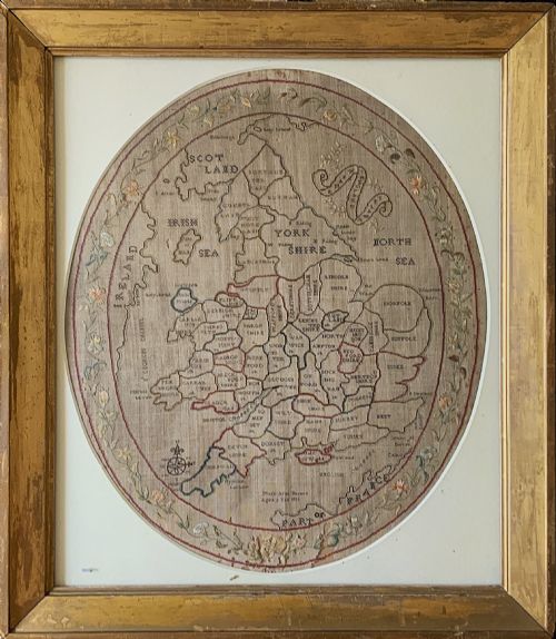
The material forms on this page divide chiefly into two categories. You find copperplate engravings on paper, often coloured by hand, and textile maps worked in silk and linen thread by young makers like Mary Banion and Mary Pinfold.
Most examples date from the eighteenth century and the early nineteenth century, spanning the Georgian and Regency periods. They arrive preserved behind glass within wooden frames, ready for wall display.
How they were made
Engravers worked designs onto copper plates using sharp tools, applying ink to transfer geographical details onto sheets of paper. Cartographers such as Robert Morden, John Cary, Eman Bowen, and Thomas Jefferys produced these foundational plates.
Needlework examples required makers to stitch maps of England and Wales onto linen grounds using coloured silk and wool threads. These textile pieces frequently combined cartographic accuracy with decorative floral borders.
Makers housed these paper and textile works inside timber surrounds, frequently utilising gilt wood or maple moulding to protect the fragile surfaces beneath glass.
Mary Banion stitched her map of England and Wales at just nine years old, securing her geography lesson in silk forever.
What varies in quality
The distinction between standard cartography and superior examples rests in the precision of the engraving and the clarity of the contemporary hand-colouring. Details such as decorative cartouches, mileage scales, and publisher imprints elevate an ordinary county survey.
For needlework samplers, quality depends upon the regularity of the stitches, the survival of the original silk threads, and the inclusion of the maker's name, age, and date of completion. Samplers executed by young hands demonstrate varying degrees of spatial skill in rendering county boundaries.
The integrity of the enclosing frame and the preservation of the paper or linen sheet determine the overall presence of the piece. Crisp impressions on clean paper outrank heavily browned or water-stained sheets.
Thomas Jefferys·Robert Morden·John Cary·Thomas Kitchin·Eman Bowen·C Smith·J Duncan·J Harrison·R Scott·John Russell
The Georgian Framed Map Glossary
- Cartography
- The science and art of making maps. This discipline defined how eighteenth-century surveyors charted counties and continents.
- Needlework sampler
- A piece of embroidery produced to demonstrate skill in various stitches. In this context, makers stitched geographical maps onto linen fabrics.
- Copperplate engraving
- A intaglio printing process where lines are cut into a copper sheet with a burin. Publishers used this method to print multiple map copies.
- Cartouche
- A decorative frame enclosing the map's title, scale, or dedication. These ornamental flourishes often feature heraldry, figures, or natural scenery.
- Giltwood
- Wood carved and coated with gold leaf or a gold-coloured finish. This material frequently appears on the frames housing fine maps and mirrors.
Georgian Framed Map: Frequently Asked Questions
What is a georgian framed map?
A georgian framed map is an authentic cartographic print or embroidered textile created during the eighteenth or early nineteenth century. These pieces record counties, countries, and continents as understood by period surveyors and geographers.
Enclosed behind glass within period wooden frames, they survive as decorative records of historical geography and domestic handcraft.
Who made needlework map samplers?
Young scholars and students created embroidered maps as part of their education in geography and needle skills. Makers stitched these pieces using silk and linen threads, frequently recording their name and age upon the fabric.
Examples like those by Mary Banion and Mary Pinfold show how textile art intersected with cartographic learning during the Regency era.
How should I hang my map?
Display your framed piece away from direct sunlight to prevent the fading of printer's ink, hand-colouring, and delicate silk threads. Stable indoor humidity protects both the antique paper and the timber frame.
Secure the piece to the wall using appropriate fixings suited to the weight of the wood and glass enclosure.
How do I identify the period?
Examine the style of the engraving, the typography of the title, and the geographical boundaries shown on the sheet. Cartographers updated their copper plates over time, reflecting shifting regional names and borders.
Manuscript details, inscriptions, and associated framing materials further help narrow the date of production.