30,034  PAGES BROWSED TODAY PAGES TODAY 75  ANTIQUES UPLOADED TODAY NEW ARRIVALS
ID #SA1113635
FOR SALE
£625
Email
Save
View and Map of London 1741
Walpoles
for sale €731     $794
£625
Walpoles

Walpoles

Sellingantiques Verified Since Mar 2024
View Dealers Stock Page
  • About Us
    Walpoles have been established for over 40 years.
  • Trade Associations
    Walpoles is a registered member of BADA 
Id #SA1113635
PDF SHARE
SAVE

View and Map of London 1741

18th century
For Sale by Walpoles
Description

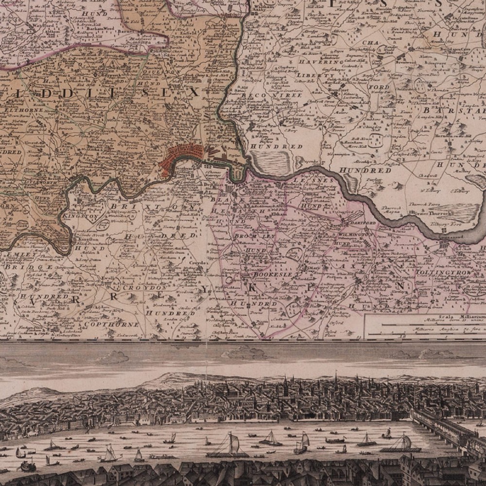
A good looking map of London and the surrounding counties published by Homann in 1741; based very largely on a similar map of the region by Thomas Bowles. London is at the centre of the sheet, coloured red, a band along the base shows a bird’s eye view of the Thames busy with a mass of barges and boats; larger shipping kept to the east by London Bridge.

The Homann map publishing house was established by Johann Baptist Homann at the end of the 17th century, passing to his son, Johann Christoph following his death in 1724. J.C in turn left the publishing house to his two principal managers, Johann Georg Ebersberger and Johann Michael Franz in 1730. Maps produced under their management are identified with the name Homann Heirs (or the suchlike), and in the present case; ‘Homanianis Heredibus 1741’.

With original colour and now within a replica eighteenth century print frame, ebonized and with a gilt sight.

o.s:25.75 in x 23.25 in

Declaration

Walpoles has dated this Framed Antique London Map to the 18th Century.

Reference Numbers
Sellingantiques Reference
SA1113635
Dealers Internal Reference
4968
Description
A good looking map of London and the surrounding counties published by Homann in 1741; based very largely on a similar map of the region by Thomas Bowles.
London is at the centre of the sheet, coloured red, a band along the base shows a bird’s eye view of the Thames busy with a mass of barges and boats; larger shipping kept to the east by London Bridge.
Walpoles
fig 1. An eighteenth-century framed antique map of London and surrounding counties featuring a panoramic cityscape view along the lower edge.
fig 1. View and Map of London 1741

The Homann map publishing house was established by Johann Baptist Homann at the end of the 17th century, passing to his son, Johann Christoph following his death in 1724. J.C in turn left the publishing house to his two principal managers, Johann Georg Ebersberger and Johann Michael Franz in 1730. Maps produced under their management are identified with the name Homann Heirs (or the suchlike), and in the present case; ‘Homanianis Heredibus 1741’.

With original colour and now within a replica eighteenth century print frame, ebonized and with a gilt sight.

o.s:25.75 in x 23.25 in

Date of Manufacture

Walpoles has dated this Framed Antique London Map to the 18th Century.

Reference Numbers
Sellingantiques Ref
SA1113635
Dealers Internal Ref
4968
Walpoles
Walpoles
Sellingantiques verified Since Mar 2024

Walpoles have been established for over 40 years.

Dealer Profile

You can view the stock and full dealer information on the Walpoles Profile Page

Trade Associations

Walpoles is a registered member of BADA 

PDF SHARE
SAVE
An eighteenth-century framed antique map of London and surrounding counties featuring a panoramic cityscape view along the lower edge.
1 / 3
Archive I An eighteenth-century framed antique map of London and surrounding counties featuring a panoramic cityscape view along the lower edge.

View and Map of London 1741

Archive II An eighteenth-century framed antique map of London and surrounding counties featuring a panoramic cityscape view along the lower edge. View II
Archive III An eighteenth-century framed antique map of London and surrounding counties featuring a panoramic cityscape view along the lower edge. View III
FURTHER BROWSING

Visitors also looked at these ⇣

Enlarged Archival View
Telephone 07831 561042
Location
111 Portobello Road
Kensington
London
W11 2QB
United Kingdom

We open on Fridays, Saturdays and Sundays.
Or by appointment.
Verified Since Mar 2024
Walpoles
Walpoles
Verified Since Mar 2024
View Dealer Info
Location: 111 Portobello Road, Kensington, London, W11 2QB, United Kingdom, , We open on Fridays, Saturdays and Sundays., Or by appointment.
Verified
Mar 2024
An eighteenth-century framed antique map of London and surrounding counties featuring a panoramic cityscape view along the lower edge.
View and Map of London 1741
Ref: SA1113635
An eighteenth-century framed antique map of London and surrounding counties featuring a panoramic cityscape view along the lower edge.
Detail View 1
Detail View 2
Archival Detail
Every single antique dealer on our platform is individually approved by our internal team. We verify their professional trade history, ethical standards, and photographic quality to ensure a secure, high-standard buying environment. Upon joining, every dealer agrees to a strict 9-point code of conduct. While issues can occasionally arise, our dealers typically resolve them swiftly and directly with the buyer. In fact, since our founding in 2002, Sellingantiques has only had to step in to help resolve an issue on roughly five occasions—a true testament to the quality of our dealers and their dedication to your happiness.
Our dealers are highly experienced in packing and shipping fragile, high-value antiques. Because you are in direct contact with the dealer, you will be able to easily go through all available shipping and insurance options together to ensure your item arrives safely.
Antiques are the ultimate green purchase. By choosing historical pieces over newly manufactured goods, you completely eliminate the carbon footprint of modern mass production while preserving exceptional, timeless craftsmanship.

Georgian cartography from the eighteenth century is characterised by detailed copperplate engravings, hand-tinted territorial boundaries, and elaborate topographical features including panoramic city views and nautical routes.

Eighteenth-century maps were typically etched or engraved into copper plates, printed onto handmade rag paper using a rolling press, and subsequently hand-coloured using watercolor washes.

Authentic period maps display a distinct plate mark impression around the border, chain lines and watermarks in the handmade paper, light oxidisation of age, and signs of original hand-colouring.

An antique map can be styled as a focal wall piece above a sideboard, desk, or mantelpiece, framed in a simple dark timber or gilt frame to bridge classic and contemporary aesthetic schemes.

Preserve antique paper works by framing them behind UV-filtering glass with acid-free mounting materials, keeping them away from direct sunlight, and maintaining a stable humidity level.
items
Add keywords to the filter
Price
£100
£250000
Era
Movements
Material
Origin
Stock Location
Freshness
Online Payments
Categories