68,757  PAGES BROWSED TODAY PAGES TODAY 319  ANTIQUES UPLOADED TODAY NEW ARRIVALS
Sort Order
Items Per Page
ID #SA1079312
FOR SALE
£100
Email
Save
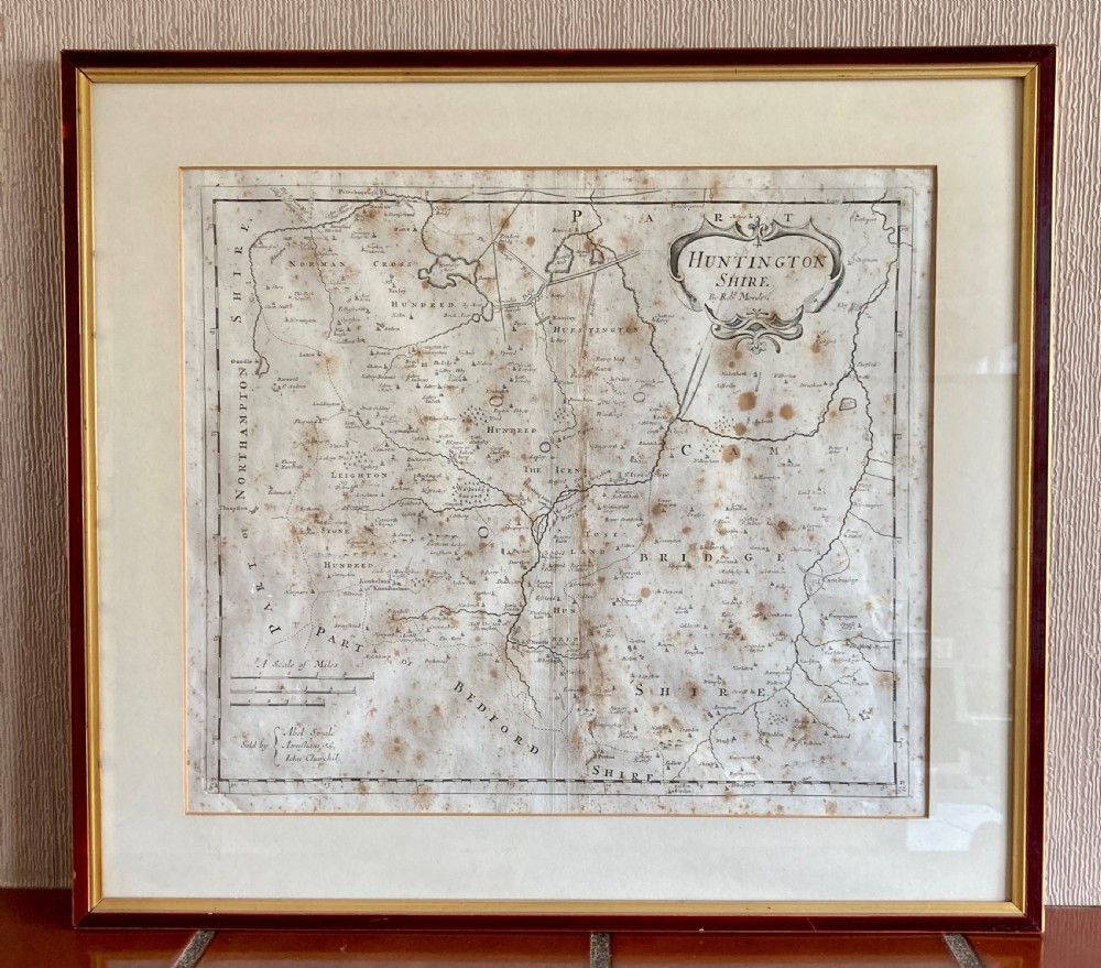
Map of Huntington Shire by Robert Morden, Circa 1722
Surrey Antiques by Gary J Hall
for sale €117     $127
£100

Surrey Antiques by Gary J Hall

Sellingantiques Verified Since Dec 2015
View Dealers Stock Page
  • About Us
    We offer a friendly and reliable service based on traditional values, where personal service and customer satisfaction are paramount..
Id #SA1079312
PDF SHARE
SAVE

Map of Huntington Shire by Robert Morden, Circa 1722

18th century
Description

This attractive map of Huntington-shire stands as a testament to the cartographic elegance of the early 18th century. Originally crafted by the esteemed cartographer Robert Morden in 1695, this map was later included in the renowned geographical work, Camden’s Britannia, around 1722.

The map is particularly distinguished by its use of three different mileage scales, a feature that underscores the precision and attention to detail that were hallmarks of Morden’s work. This inclusion would have been of immense practical value at the time, offering viewers a versatile tool for gauging distances across the shire.

The visual appeal of the map is undeniable, with its intricate detailing and attractive design. It not only serves as a navigational aid but also as a piece of art, capturing the essence of Huntington-shire during a period of significant historical importance.

As a historical artifact, the map provides a window into the past, offering insights into the county’s geography as understood in the late 17th and early 18th centuries. It is a remarkable piece that would be a valuable addition to any collection, appealing to both historians and connoisseurs of cartography alike.

Frame: 23 inches x 20 1/2 inches (58.5 cm x 52 cm)

Physical Dimensions
Height
52cm (20.47")
Width
58.5cm (23.03")
Declaration

Surrey Antiques by Gary J Hall has dated this Robert Morden Antique Map to the 18th Century.

Reference Numbers
Sellingantiques Reference
SA1079312
Dealers Internal Reference
SA197
Dealers Notes

Surrey Antiques have been dealing in and restoring fine furniture since 1982. With over 35 years experience dealing in all types of antique furniture from early oak and walnut to Georgian mahogany and the more exotic timbers such as rosewood and satinwood.

Whilst we deal mostly with mahogany furniture of the Georgian period designed by some of the greatest furniture designers such as Chippendale, Sheraton, Hepplewhite and Adam we also have a very good in depth knowledge of all the main periods of English furniture design from early oak to Regency and Victorian.

Description
This attractive map of Huntington-shire stands as a testament to the cartographic elegance of the early 18th century.
Originally crafted by the esteemed cartographer Robert Morden in 1695, this map was later included in the renowned geographical work, Camden’s Britannia, around 1722.
Surrey Antiques by Gary J Hall
fig 1. An 18th-century engraved map of Huntington Shire by Robert Morden, set within a cream mount and a dark wood frame with a gilt inner slip.
fig 1. Map of Huntington Shire by Robert Morden, Circa 1722

The map is particularly distinguished by its use of three different mileage scales, a feature that underscores the precision and attention to detail that were hallmarks of Morden’s work. This inclusion would have been of immense practical value at the time, offering viewers a versatile tool for gauging distances across the shire.

fig 2. An 18th-century engraved map of Huntington Shire by Robert Morden, set within a cream mount and a dark wood frame with a gilt inner slip.
fig 2. Map of Huntington Shire by Robert Morden, Circa 1722

The visual appeal of the map is undeniable, with its intricate detailing and attractive design. It not only serves as a navigational aid but also as a piece of art, capturing the essence of Huntington-shire during a period of significant historical importance.

fig 3. An 18th-century engraved map of Huntington Shire by Robert Morden, set within a cream mount and a dark wood frame with a gilt inner slip.
fig 3. Map of Huntington Shire by Robert Morden, Circa 1722

As a historical artifact, the map provides a window into the past, offering insights into the county’s geography as understood in the late 17th and early 18th centuries. It is a remarkable piece that would be a valuable addition to any collection, appealing to both historians and connoisseurs of cartography alike.

Frame: 23 inches x 20 1/2 inches (58.5 cm x 52 cm)

Height
52cm (20.47")
Width
58.5cm (23.03")
Date of Manufacture

Surrey Antiques by Gary J Hall has dated this Robert Morden Antique Map to the 18th Century.

Reference Numbers
Sellingantiques Ref
SA1079312
Dealers Internal Ref
SA197
Surrey Antiques by Gary J Hall
Sellingantiques verified Since Dec 2015

We offer a friendly and reliable service based on traditional values, where personal service and customer satisfaction are paramount..

Dealer Profile

You can view the stock and full dealer information on the Surrey Antiques by Gary J Hall Profile Page
PDF SHARE
SAVE
An 18th-century engraved map of Huntington Shire by Robert Morden, set within a cream mount and a dark wood frame with a gilt inner slip.
1 / 7
Archive I An 18th-century engraved map of Huntington Shire by Robert Morden, set within a cream mount and a dark wood frame with a gilt inner slip.

Map of Huntington Shire by Robert Morden, Circa 1722

Archive II An 18th-century engraved map of Huntington Shire by Robert Morden, set within a cream mount and a dark wood frame with a gilt inner slip. View II
Archive III An 18th-century engraved map of Huntington Shire by Robert Morden, set within a cream mount and a dark wood frame with a gilt inner slip. View III
Archive IV An 18th-century engraved map of Huntington Shire by Robert Morden, set within a cream mount and a dark wood frame with a gilt inner slip. View IV
Archive V An 18th-century engraved map of Huntington Shire by Robert Morden, set within a cream mount and a dark wood frame with a gilt inner slip. View V
Archive VI An 18th-century engraved map of Huntington Shire by Robert Morden, set within a cream mount and a dark wood frame with a gilt inner slip. View VI
Archive VII An 18th-century engraved map of Huntington Shire by Robert Morden, set within a cream mount and a dark wood frame with a gilt inner slip. View VII
Enlarged Archival View
Location
Unit 7A
Pankhurst Farm
Bagshot Road
West End
Surrey
United Kingdom
Verified Since Dec 2015
Items For Sale 71
Items Sold 115
Surrey Antiques by Gary J Hall
Verified Since Dec 2015
View Dealer Info
Location: Unit 7A, Pankhurst Farm, Bagshot Road, West End, Surrey, United Kingdom
Verified
Dec 2015
For Sale
71
Sold
115
An 18th-century engraved map of Huntington Shire by Robert Morden, set within a cream mount and a dark wood frame with a gilt inner slip.
Map Of Huntington Shire By Robert Morden, Circa 1722
Ref: SA1079312
An 18th-century engraved map of Huntington Shire by Robert Morden, set within a cream mount and a dark wood frame with a gilt inner slip.
Detail View 1
Detail View 2
Detail View 3
Detail View 4
Detail View 5
Detail View 6
Archival Detail
Every single antique dealer on our platform is individually approved by our internal team. We verify their professional trade history, ethical standards, and photographic quality to ensure a secure, high-standard buying environment. Upon joining, every dealer agrees to a strict 9-point code of conduct. While issues can occasionally arise, our dealers typically resolve them swiftly and directly with the buyer. In fact, since our founding in 2002, Sellingantiques has only had to step in to help resolve an issue on roughly five occasions—a true testament to the quality of our dealers and their dedication to your happiness.
Our dealers are highly experienced in packing and shipping fragile, high-value antiques. Because you are in direct contact with the dealer, you will be able to easily go through all available shipping and insurance options together to ensure your item arrives safely.
Antiques are the ultimate green purchase. By choosing historical pieces over newly manufactured goods, you completely eliminate the carbon footprint of modern mass production while preserving exceptional, timeless craftsmanship.

Robert Morden was an English cartographer and printseller active in the late 17th and early 18th centuries. His county maps were featured in Edmund Gibsons edition of Camdens Britannia, incorporating updated road routes based on John Ogilbys surveys along with distinctive ornamental cartouches.

Maps from this era were printed from engraved copper plates onto handmade linen rag paper using oil-based ink. These impressions were created using a rolling press, leaving a distinct indented plate mark around the printed border.

Authentic prints feature clear plate marks, hand-laid rag paper with chain lines visible when backlit, and period-appropriate typography. Natural aging typically results in mild paper toning, oxidation marks, or foxing across the surface.

Framed antique maps work well as decorative focal points in study areas, entryways, or arranged within a gallery wall on a staircase. Framing with neutral acid-free mounts and classic moulding allows the piece to complement both modern and traditional interiors.

Store or display paper prints away from direct sunlight, utilizing UV-filtering glass and archival mount boards to avoid discolouration. Maintain stable humidity levels to prevent paper warping and the development of foxing spots.
items
Add keywords to the filter
Price
£100
£250000
Era
Movements
Material
Origin
Stock Location
Freshness
Online Payments
Categories